MENU


    [recaptcha size:compact]

    Oil & Gas

    Oil & Gas Exploration

    AGI Surveys for Oil and Gas Exploration, are used to explore for gas, condensate, and oil hydrocarbons, both onshore and offshore, in all terrains, geographies and climates. AGI’s unique technology has been used in over 70 countries with climates ranging from frozen tundra to dry desert to tropical jungle. It has been used to derisk frontier exploration, maximize production in field development, map hydrocarbon charge in areas with limited seismic clarity such as thick salt sequences, channel sands, or thrust belts, evaluate fields with heavy oil or stacked pay, and define sweet spots with enhanced porosity, pressure and hydrocarbon richness in shale plays.

    Proven Results

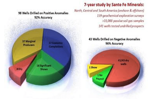
    As published in AAPG Memoir 66 by Santa Fe Minerals, AGI surveys were combined with 3D seismic over a seven year period in North, Central, and South America for both onshore and offshore application. The AGI data correctly predicted 131 of the 141 post-survey wells. Ninety-six percent of the dry wells and ninety-two percent of the producing wells were correctly predicted. By the end of the seven year period, Santa Fe Minerals was able to reduce their exploration costs by approximately 58% !!

    Comparative Methods

    Many traditional methods have the benefit of being inexpensive screening techniques that in some cases can detect near-surface gas or liquid hydrocarbons. However, these methods aresubject to a lack of sensitivity and specificity, and consequently have higher false positive and false negative rates.

    In addition, these older technologies do not work well in stacked pay scenarios, lacking the capability to discriminate and differentiate hydrocarbon signatures from multiple formations or
    depths.

    Historical Background

    Scientists have used surface geochemical techniques since 1930 to explore for hydrocarbons. These techniques look for the effects of minute levels of hydrocarbons that leak through imperfect seals and migrate as macroseepage via faults or as microseepage vertically through reservoir overburden (Klusman, 1993; Coleman et. al. 1997; Anderson, 2006). Early methodologies included soil analysis, soil gas analysis, iodine mapping, and microbial counting. These methods were often unreliable and disappointing due to:

    • an inability to cope with heterogeneous soil characteristics such as permeability, moisture, and organic content
    • heavy losses in compound due to poor sampling techniques(Hewitt and Lukash, 1996)
    • monitoring indirect and unreliable proxies (e.g. microbes, iodine) rather than directhydrocarbon measurement
    • poor sensitivity (parts per million vs parts per billion)
    • severely limited compound range (C1-C5)
    • failure to use statistical tools to differentiate between thermogenic and background signatures

    Advantages of the AGI Method:

    • it is a direct hydrocarbon measurement method (thus it is not subject to interferences or false positives from near-surface soil conditions
      as are indirect methods),
    • 1,000 times more sensitive than other methods,
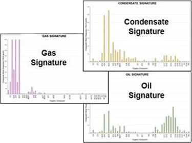
    • measures over 100 compounds from C2-C20, providing a unique ability to clearly define and differentiate multiple gas, gas condensate, and oil
      signatures,
    • has a >90% success rate at predicting dry hole, thus reducing exploration risk and drilling costs,
    • can clearly differentiate between multiple gas, condensate, and oil signatures,
    • can identify stacked pay and multiple petroleum systems.

    Frequently Asked Questions

    © 2025 Amplified Geochemical Imaging, All Rights Reserved.